Weather information and latest information on mountain huts and mountains
mikketa
(Mikke)

A number of useful sources of information are available, including the Northern Alps, the Southern Alps, the Hundred Peaks of Japan and the Hundred Peaks of Flowers, as well as the latest information on "now" related to mountain areas such as mountains and huts nationwide.
Above all, the weather information you care about is, every 1 time from up to 8 days ahead.
You can see the weather forecast for the mountain top. It is also possible to print weather forecasts on 1 sheets from a PC.
The total number of "mikketa" recorded is 2000 or more.All services can be used free of charge without membership registration.
About mikketa
One of the most important things in preparation for going to the outdoor field, including climbing, is to make a plan. It brought together all the fresh information needed.
Where to go, when planning while bouncing the mind,
If you could get the information you were asking for "mikketa" here.
I made mikketa with such thoughts.
Wind direction, wind speed, rain and snow, air temperature, atmospheric pressure, sunrise on the day, cloud load, 1 time-series weather forecast, 48 time detailed weather forecast, XNUM X day detailed weather forecast, weather so much.
In addition, Geographical Survey Institute topographic map, applicable "" Yama-To-Kogen-Chizu "map", GoogleMap aerial photograph, YouTube video, Twitter · Facebook etc SNS, mountain record list, car, train, bus, Access method and reservation guidance by air, distance to the nearest station, word-of-mouth information, tent area, presence of water place, bath / bathing facility existence, day bathing availability, cell phone area, nearby mountain / facility list, by Jalan hotel reservation.
Of course, if it is mountain, altitude, latitude and longitude, if it is facility, business period, address, contact information.
All these things "mikketa"
As supporter of everybody enjoying mountain climbing and mountain trip, outdoor activity,
Please use it as a mountain weather site that can be used free of charge, in order to enjoy substantial mountain climbing and activities.
I hope that the trip starting with mikketa will be a trip for everyone.
The "mikketa list" is useful when you do not need to search by a specific search word or when you want to look at the listed items in order. This is a list of mountain related accommodation and mountains including all mountain huts listed in mikketa.
Whether it is a hut or a mountain, each individual page will also show the ones that are registered with mikketa in the neighborhood.
Since all of them are displayed on the map together in order of distance, it is easy to grasp the positional relationship. You can filter the display under various conditions, sort by elevation, latitude, reading, etc.
Accommodation in mountainous areas, adjacent areas, mountain huts etc. It also includes shelter cabins.
Hokkaido
Douhoku, Rishiri / Akan, Shiretoko / Mt. Taisetsuzan / Mt. Tokachidake / Mt. Yubaridake / Mt. Ashibetsudake / Hidaka mountain range / Sapporo, around Otaru / Mt. Youteizan, Niseko / Shikotsu, Touya, Mt. Karibayama, around Hakodate
Tohoku North
Hakkoda, Mt. Iwakisan / Hachimantai, Akitakoma, Mt. Iwatesan, Mt. Moriyoshizan / Hayachine, around Mt. Kurikomayama / Mt. Chokaisan
Tohoku South
Mt. Gassan, Haguro, Mt. Yudonosan / around Mt. Funagatayama, Zao mountain range / Asahi mountain range / Iide mountain range / Azuma, Adatara, Mt. Bandaisan
Nasu, Nikko, Oze
Nasu mountain range, Oku Kinu, Nikko / Oze, Minamiaizu
Joshinetsu
Sado / Sumon, Asakusa, Mt. Mikaguradake / Echigosanzan, Ginzanko / Mt. Naebayama, Kiyotsukyo / Tanikawa mountain range, Makihata, Hotakayama / Joshin border, Shiga, Kusatsu, Asama / Jyomosanzan, Nishijoshu / Amakazari, Myoko, Togakushi
Okutama, Takao, Daibosatsu
Kumotori, Okutama, Takao / Daibosatsu
Oku Chichibu, Kinpu, Kobushi
Mt. Ryokamisan, Chichibu, Oku Musashi / Kobushi, Jumonjitouge, Kinpu, Minami Saku / Mt. Kentokusan, Mt. Konarayama
Tanzawa
Higashi Tanzawa / Nishi Tanzawa, Doushi
Mt. Fujisan, Izu
Mt. Fujisan Fujinomiyaguchi / Mt. Fujisan Gotenbaguchi / Mt. Fujisan Subashiriguchi / Mt. Fujisan Yoshidaguchi / Misaka, Mitsutouge, Mt. Ashitakayama / Izu / Ooshima
Main facilities
Sato Goya
Taishikan
Gansomuro
Edoya (Shimoedoya)
Fujisan Hotel
Goraikokan
Japan Southern Alps
Kaikoma, Senjo / Houousanzan / Yashajin, Amari / Mt. Kitadake / around Mt. Ainodake, Narada, Shiomi, Mt. Kogouchi / around Mt. Arakawadake / Mt. Akaishidake, Sawarajima / Mt. Hijiridake, Mt. Tekaridake / Mt. Nyugasayama
Main facilities
Schijo Goya
Senjo hut
Kitadake Sanso
Farm aviary
Shiomi hut
Shizuoka Akaishi Hut
Kashiwa Lodge
Yatsugatake
Amikasa, Gongen, Minoto / Mt. Akadake, Mt. Ioudake / Kita Yatsugatake, Tateshina / around Mt. Tengudake / Kirigamine / Utsukushigahara
Japan Northern Alps
Toyama city, around Tateyama city, Midagahara, Dainichi / Tateyama, Murodo / Mt. Tsurugidake, Uratsurugi / Kurobe, Yakushi / Unaduki, Keyakidaira, around Kurobe / Hakuba / Tsugami, Yukikura, Mt. Asahidake / around Mt. Harinokidake / Karamatsu, Goryu, Kashimayari, around Omoteginza, Jonen mountain range / around Kumonodaira, Omoteginza / Sugoroku, Mt. Kasagatake / Kamikochi, Taishoike / around Kamikochi, Mt. Yakedake / Karasawa, Hotaka / Mt. Yarigatake
Main facilities
Hakuba Ooike Sanso
Hakuba Sanso
Shiroumadake tyojo shukusya
Goryu Sanso
Azohara Onsen Goya
Mt. Tsurugisan Zhuang
Mikurigaike Onsen
Mt. Yakushidake Sanso
Taro flat hut
Noguchi Goro Hut
Unnohirayamaso
Enzanso
Mitaka Sanso
Goro Kurobe
Twin six cabin
Daitenso
Yarigatake Sanso
Killing Hutte
Changen hut
Mt. Kasagatake Sanso
Kitahotaka hut
Karasawa Goya
Karasawa Hutte
Hotakadake Sanso
Chogatake Hutte
Takezawa hut
Nishiho Sanso
Konashidaira Camp Site
Kamikochi Nishiitoya Sanso
Kamikochi Imperial Hotel
Norikura, Ontake
Mt. Norikura / Mt. Ontake
Japan Central Alps
Central Alps / Mt. Enasan
Hakusan, Mt. Arashimadake
Hakusan, around Hakusan / Mt. Arashimadake
Kinki
Mt. Ibukiyama, Suzuka Mountains / Hira, Kongo, Kitayama, Hokusetsu / Kouya, Oomine, Daikou
Chugoku, Shikoku
Mt. Daisen, Mt. Hiruzen, Mt. Hyonosen / Mt. Ishiwariyama, Shikoku karst / Mt. Tsurugisan
Kyushu・Okinawa
Kitakyushu / Hizen / Yufu, Tsurumi / Kuju mountain range / Mt. Asozan / Sobo, Katamuki, Ookue / Ichifusa, Osuzu, Mt. Boroishiyama / Kirishima mountain range / Nansatsu, Yakushima / Okinawa
Including various hundred famous mountains such as one hundred famous mountains in Japan, we publish mountains of the whole country.
Main mountain
Mt. Taisetsuzan (Asahidake)
Mt. Chokaisan (Shinzan)
Mt. Iidesan
Mt. Hiuchigatake
Mt. Shiroumadake
Mt. Tateyama (Mt. Oonanjiyama)
Mt. Yakushidake
Mt. Hakusan (Gozenmine)
Mt. Kumotoriyama
Mt. Kiso Komagatake
Mt. Kai Komagatake
Mt. Shiomidake
Mt. Daisen (Kengamine)
Mt. Hakkyogatake (Mt. Oomineyama)
Mt. Tsurugisan
Mt. Ishiduchiyama (Mt. Tengudake)
Kujurenzan (Mt. Kujusan) (Mt. Nakadake)
Main mountain
Mt. Ishikaridake
Mt. Yakeishidake
Mt. Akita Komagatake (Mt. Onamedake)
Mt. Hakkaisan (Mt. Nyudoudake)
Mt. Yukikuradake
Mt. Oku Dainichidake
Mt. Harinokidake
Mt. Eboshidake
Mt. Tsubakurodake
Mt. Otenshodake
Mt. Tengudake
Mt. Hyonosen (Suganosen)
Mt. Gozaishoyama
Mt. Hiruzen (Mt. Kamihiruzen)
Mount Kirishima (Takachihoho)
Main mountain
Mt. Shokanbetsudake
Mt. Tarumaesan
Mt. Hayachinesan
Mt. Gassan
Mt. Adatarayama (Mt. Tetsuzan)
Mt. Hiuchiyama
Mt. Shibutsusan
Mt. Naebayama
Mt. Akagiyama (Mt. Kurohiyama)
Goshikigahara
Mt. Kurofuyama
Mt. Kurobegorodake (Mt. Nakanomatadake)
Mt. Sugorokudake
Mt. Nishi Hotakadake
Kirigamine (Kurumayama)
Mt. Bukousan
Mt. Kinpusan
Mt. Kawanoriyama
Mt. Oodakesan
Mt. Takaosan
Mt. Amagisan (Mt. Banzaburodake)
Mt. Sobosan
Main mountain
Mt. Rausudake
Hachimantai
Mt. Sumondake
Mt. Aizu Komagatake
Mt. Myokosan
Mt. Hotakayama (Mt. Jousyu Hotakayama)
Mt. Okushiranesan (Mt. Nikko Shiranesan)
Mt. Kashima Yarigatake
Mt. Kitanomatadake (Mt. Kaminodake)
Mt. Asamayama
Mt. Kasagatake
Mt. Tateshinayama
Mt. Ryokamisan
Mt. Kobushidake (Mt. Kobushigatake)
Mt. Mitakesan (Mt. Bushu Mitakesan)
Mt. Daibosatsurei (Mt. Daibosatsudake)
Mt. Senjogatake (Senjodake)
Hoousanzan (Mt. Houousan) (Mt. Kannongatake)
Mt. Enasan
Mt. Asozan (Mt. Takadake)
SIM CONNECT
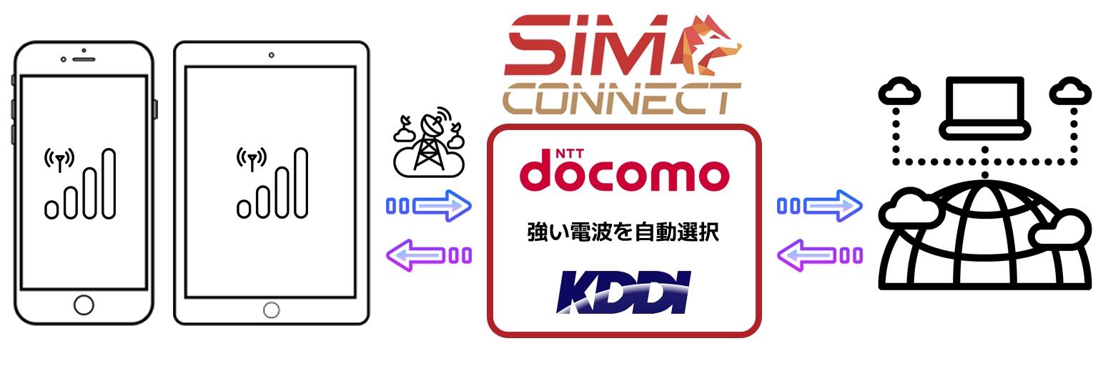
SIMCONNECT is a multi-carrier SIM that expands the service area by allowing you to use both NTTdocomo (1G/5G/4G) and KDDI (au3G) radio waves (mobile data communication line) with one eSIM. It is also effective for disaster prevention. Specifically here →
・ This weather forecast uses the forecast announced by the Norwegian National Institute of Meteorology (MET: Norwegian Metrological Institute). It is announced as a weather forecast in Norway and distributed throughout the world, but in Japan there is also an interpretation as a numerical forecast, so please keep this in mind.
-Since the weather forecast announced by MET is displayed without making its own judgment, some notations may not be translated into Japanese.
・ This weather forecast is a forecast to the last, and please note that we can not guarantee the certainty and accuracy of the information in PORTALFIELD.
• Weather conditions may change rapidly in mountainous areas. Be sure to check not only the weather forecast, but also the actual weather conditions, the warnings and warnings issued, etc., and keep safety in mind.
・ We can not bear responsibility such as damage that occurred by having used information of this site including this information in PORTALFIELD. Please note in advance, please check the terms and conditions in detail.
mikketa recommended articles
Let's check the weather of the mountain! One of the information you must know before climbing is the weather on the mountain. Even when the weather is stable, even if you walk on a mountain without much difficulty, if the weather conditions get worse, life-threatening situations may occur.

mikketa
Mountain hut and mountain
Weather forecast and latest information
Accommodation in mountainous areas, adjacent areas, mountain huts etc. It also includes shelter cabins.
Hokkaido
Douhoku, Rishiri / Akan, Shiretoko / Mt. Taisetsuzan / Mt. Tokachidake / Mt. Yubaridake / Mt. Ashibetsudake / Hidaka mountain range / Sapporo, around Otaru / Mt. Youteizan, Niseko / Shikotsu, Touya, Mt. Karibayama, around Hakodate
Tohoku North
Hakkoda, Mt. Iwakisan / Hachimantai, Akitakoma, Mt. Iwatesan, Mt. Moriyoshizan / Hayachine, around Mt. Kurikomayama / Mt. Chokaisan
Tohoku South
Mt. Gassan, Haguro, Mt. Yudonosan / around Mt. Funagatayama, Zao mountain range / Asahi mountain range / Iide mountain range / Azuma, Adatara, Mt. Bandaisan
Nasu, Nikko, Oze
Nasu mountain range, Oku Kinu, Nikko / Oze, Minamiaizu
Joshinetsu
Sado / Sumon, Asakusa, Mt. Mikaguradake / Echigosanzan, Ginzanko / Mt. Naebayama, Kiyotsukyo / Tanikawa mountain range, Makihata, Hotakayama / Joshin border, Shiga, Kusatsu, Asama / Jyomosanzan, Nishijoshu / Amakazari, Myoko, Togakushi
Okutama, Takao, Daibosatsu
Kumotori, Okutama, Takao / Daibosatsu
Oku Chichibu, Kinpu, Kobushi
Mt. Ryokamisan, Chichibu, Oku Musashi / Kobushi, Jumonjitouge, Kinpu, Minami Saku / Mt. Kentokusan, Mt. Konarayama
Tanzawa
Higashi Tanzawa / Nishi Tanzawa, Doushi
Mt. Fujisan, Izu
Mt. Fujisan Fujinomiyaguchi / Mt. Fujisan Gotenbaguchi / Mt. Fujisan Subashiriguchi / Mt. Fujisan Yoshidaguchi / Misaka, Mitsutouge, Mt. Ashitakayama / Izu / Ooshima
Main facilities
Sato Goya
Taishikan
Gansomuro
Edoya (Shimoedoya)
Fujisan Hotel
Goraikokan
Japan Southern Alps
Kaikoma, Senjo / Houousanzan / Yashajin, Amari / Mt. Kitadake / around Mt. Ainodake, Narada, Shiomi, Mt. Kogouchi / around Mt. Arakawadake / Mt. Akaishidake, Sawarajima / Mt. Hijiridake, Mt. Tekaridake / Mt. Nyugasayama
Main facilities
Schijo Goya
Senjo hut
Kitadake Sanso
Farm aviary
Shiomi hut
Shizuoka Akaishi Hut
Kashiwa Lodge
Yatsugatake
Amikasa, Gongen, Minoto / Mt. Akadake, Mt. Ioudake / Kita Yatsugatake, Tateshina / around Mt. Tengudake / Kirigamine / Utsukushigahara
Japan Northern Alps
Toyama city, around Tateyama city, Midagahara, Dainichi / Tateyama, Murodo / Mt. Tsurugidake, Uratsurugi / Kurobe, Yakushi / Unaduki, Keyakidaira, around Kurobe / Hakuba / Tsugami, Yukikura, Mt. Asahidake / around Mt. Harinokidake / Karamatsu, Goryu, Kashimayari, around Omoteginza, Jonen mountain range / around Kumonodaira, Omoteginza / Sugoroku, Mt. Kasagatake / Kamikochi, Taishoike / around Kamikochi, Mt. Yakedake / Karasawa, Hotaka / Mt. Yarigatake
Main facilities
Hakuba Ooike Sanso
Hakuba Sanso
Shiroumadake tyojo shukusya
Goryu Sanso
Azohara Onsen Goya
Mt. Tsurugisan Zhuang
Mikurigaike Onsen
Mt. Yakushidake Sanso
Taro flat hut
Noguchi Goro Hut
Unnohirayamaso
Enzanso
Mitaka Sanso
Goro Kurobe
Twin six cabin
Daitenso
Yarigatake Sanso
Killing Hutte
Changen hut
Mt. Kasagatake Sanso
Kitahotaka hut
Karasawa Goya
Karasawa Hutte
Hotakadake Sanso
Chogatake Hutte
Takezawa hut
Nishiho Sanso
Konashidaira Camp Site
Kamikochi Nishiitoya Sanso
Kamikochi Imperial Hotel
Norikura, Ontake
Mt. Norikura / Mt. Ontake
Japan Central Alps
Central Alps / Mt. Enasan
Hakusan, Mt. Arashimadake
Hakusan, around Hakusan / Mt. Arashimadake
Kinki
Mt. Ibukiyama, Suzuka Mountains / Hira, Kongo, Kitayama, Hokusetsu / Kouya, Oomine, Daikou
Chugoku, Shikoku
Mt. Daisen, Mt. Hiruzen, Mt. Hyonosen / Mt. Ishiwariyama, Shikoku karst / Mt. Tsurugisan
Kyushu・Okinawa
Kitakyushu / Hizen / Yufu, Tsurumi / Kuju mountain range / Mt. Asozan / Sobo, Katamuki, Ookue / Ichifusa, Osuzu, Mt. Boroishiyama / Kirishima mountain range / Nansatsu, Yakushima / Okinawa
Access Ranking
This is the ranking of the number of past XNUM X days of accommodation, such as mountain huts listed in mikketa.
Including various hundred famous mountains such as one hundred famous mountains in Japan, we publish mountains of the whole country.
Main mountain
Mt. Taisetsuzan (Asahidake)
Mt. Chokaisan (Shinzan)
Mt. Iidesan
Mt. Hiuchigatake
Mt. Shiroumadake
Mt. Tateyama (Mt. Oonanjiyama)
Mt. Yakushidake
Mt. Hakusan (Gozenmine)
Mt. Kumotoriyama
Mt. Kiso Komagatake
Mt. Kai Komagatake
Mt. Shiomidake
Mt. Daisen (Kengamine)
Mt. Hakkyogatake (Mt. Oomineyama)
Mt. Tsurugisan
Mt. Ishiduchiyama (Mt. Tengudake)
Kujurenzan (Mt. Kujusan) (Mt. Nakadake)
Main mountain
Mt. Ishikaridake
Mt. Yakeishidake
Mt. Akita Komagatake (Mt. Onamedake)
Mt. Hakkaisan (Mt. Nyudoudake)
Mt. Yukikuradake
Mt. Oku Dainichidake
Mt. Harinokidake
Mt. Eboshidake
Mt. Tsubakurodake
Mt. Otenshodake
Mt. Tengudake
Mt. Hyonosen (Suganosen)
Mt. Gozaishoyama
Mt. Hiruzen (Mt. Kamihiruzen)
Mount Kirishima (Takachihoho)
Main mountain
Mt. Shokanbetsudake
Mt. Tarumaesan
Mt. Hayachinesan
Mt. Gassan
Mt. Adatarayama (Mt. Tetsuzan)
Mt. Hiuchiyama
Mt. Shibutsusan
Mt. Naebayama
Mt. Akagiyama (Mt. Kurohiyama)
Goshikigahara
Mt. Kurofuyama
Mt. Kurobegorodake (Mt. Nakanomatadake)
Mt. Sugorokudake
Mt. Nishi Hotakadake
Kirigamine (Kurumayama)
Mt. Bukousan
Mt. Kinpusan
Mt. Kawanoriyama
Mt. Oodakesan
Mt. Takaosan
Mt. Amagisan (Mt. Banzaburodake)
Mt. Sobosan
Main mountain
Mt. Rausudake
Hachimantai
Mt. Sumondake
Mt. Aizu Komagatake
Mt. Myokosan
Mt. Hotakayama (Mt. Jousyu Hotakayama)
Mt. Okushiranesan (Mt. Nikko Shiranesan)
Mt. Kashima Yarigatake
Mt. Kitanomatadake (Mt. Kaminodake)
Mt. Asamayama
Mt. Kasagatake
Mt. Tateshinayama
Mt. Ryokamisan
Mt. Kobushidake (Mt. Kobushigatake)
Mt. Mitakesan (Mt. Bushu Mitakesan)
Mt. Daibosatsurei (Mt. Daibosatsudake)
Mt. Senjogatake (Senjodake)
Hoousanzan (Mt. Houousan) (Mt. Kannongatake)
Mt. Enasan
Mt. Asozan (Mt. Takadake)
Access Ranking
It is the ranking of the number of access of the past XNUM X days in the mountain published in mikketa.
PORTALFIELD Twitter Weather Information
PORTALFIELD's official Twitter (@portalfieldcom) In the account, I am tweeting the weather forecast of the 15 time of the next day and the day after next about the mountains in various places from around 9 every day.
SIM CONNECT
SIMCONNECT is a multi-carrier SIM that expands the service area by allowing you to use both NTTdocomo (1G/5G/4G) and KDDI (au3G) radio waves (mobile data communication line) with one eSIM. It is also effective for disaster prevention. Specifically here →
mikketa recommended articles
Let's check the weather of the mountain! One of the information you must know before climbing is the weather on the mountain. Even when the weather is stable, even if you walk on a mountain without much difficulty, if the weather conditions get worse, life-threatening situations may occur.